
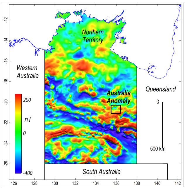
A new map of Australia has revealed a strange indentation in the magnetic field beneath Australia’s Northern Territory.
The Australian Magnetic Anomaly Zone, named for the country’s resemblance in shape, holds valuable information about Australia’s geological history, including how different rock formations formed and acquired their unique magnetic properties.
you may like
Magnetic anomalies are local variations in the Earth’s magnetic field caused by the magnetic properties of certain minerals and rocks, such as iron ore deposits within the Earth’s crust.
From the moment rocks are formed, they begin to develop magnetic signatures that incorporate information about the direction of the Earth’s magnetic field at that particular point in time. This “magnetic memory”, known as residual magnetism, helps scientists reconstruct a rock’s past.
But the magnetic field sometimes flips, and tectonic movements can change the orientation of rocks, confusing the situation. But if scientists can decipher the clues encoded in a rock’s magnetic signature, they can reconstruct exactly what a rock passed through and when.
Australia’s magnetic anomalies include structures such as faults, folds and basins that cannot be detected using traditional mapping techniques, the statement said. To explore these hidden layers, Foss and his team used advanced modeling techniques to better visualize magnetic data collected during the Northern Territory government’s 1999 Bonny Well survey.
For the study, planes fitted with magnetometers, devices that measure magnetic fields, flew over the Northern Territory in a fixed line about 1,300 feet (400 meters) apart. Scientists previously attempted to map these data, but the maps did not always show the magnetic signals clearly, especially along the flight path, according to the statement.
New modeling solved this problem. “My colleague Dr. Aaron Davis has created an innovative grid algorithm that improves the dataset and produces cleaner, more consistent images,” Foss said. “By improving the way these datasets are processed and modeled, we will be able to extract more geological information than ever before.”
The researchers identified subtle magnetic layers, buried geological boundaries and structures that had gone undetected by previous mapping.
Although the research team is still working on the interpretation of these findings, preliminary results indicate that the western edge of the Australian magnetic anomaly is exposed at the surface of the Hatches Creek Formation in the Northern Territory. The Hatches Creek Formation is a geological unit composed of sandstone and volcanic rock that was deposited between 2.5 and 1.6 billion years ago.
Ultimately, mapping Australia’s magnetic anomalies could lead to important geological discoveries, including opportunities for resource exploration, the statement said. Companies and the Australian government could benefit from research that creates more detailed maps of mineral deposits.
Source link