
Western states are expected to face a higher-than-usual wildfire threat this summer, according to the latest forecast released Wednesday by the National Interagency Coordination Center.
The government-run center publishes monthly reports predicting fire risks for the next four months, but the change from March’s outlook is startling. The agency shows increased risk in red on its maps, and the June forecast from March 2 showed a small band of red in the southwest. But due to an ongoing snow drought, rapid snowmelt, and a recent unprecedented heat wave, the latest maps feature a red color extending from the Southwest to the Rocky Mountains, Pacific Northwest, and northern California.
you may like
In a normal year, he said, many mountain ranges are covered in snow and snowmelt can be seen soaking the landscape in June. This year is different.
The latest forecast reports that the snow in the Four Corners region is not only melting “weeks to months earlier than normal, but also four to six weeks earlier than the earliest recorded snow melt date.” The recent heat wave has also dried out the West. For example, the city of Albuquerque had its earliest recorded temperature of 90 degrees on March 21, more than six weeks earlier than the previous record set in 1947. Las Vegas recorded an average daily temperature of 73.1 degrees in March, breaking the city’s April record.
Image 1/2
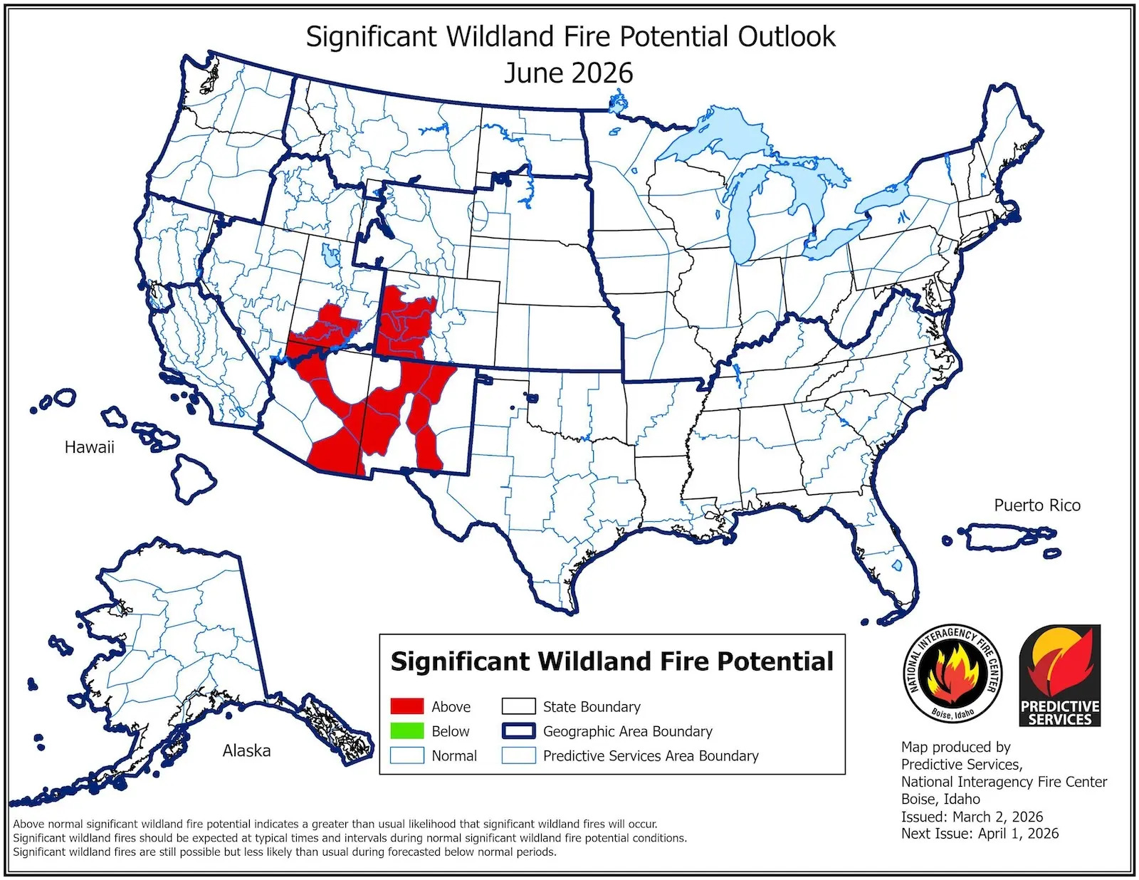
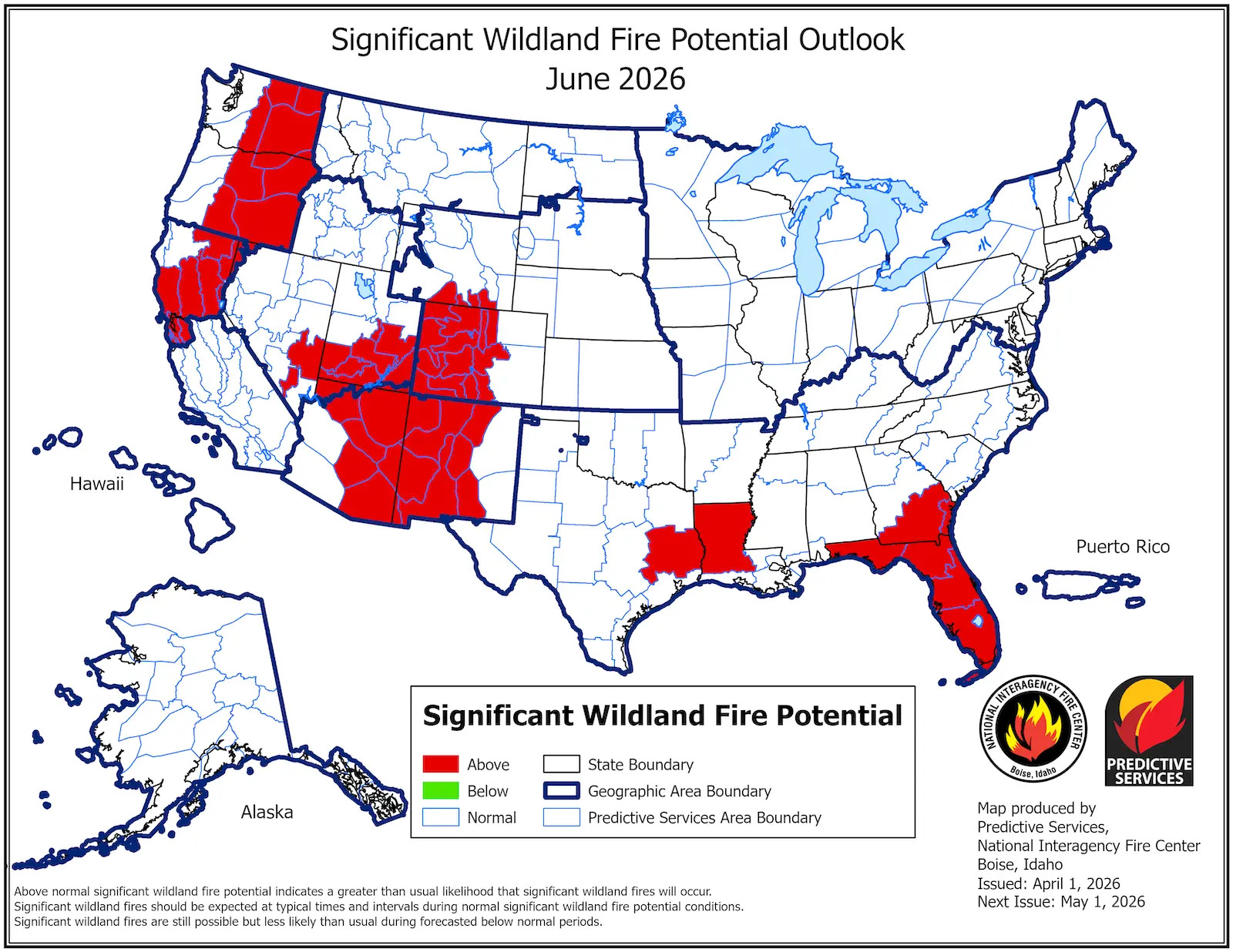
Overall, we have had less snow and warmer temperatures than any other winter on record. This is a situation that climatologists say is virtually impossible without climate change, and the map reflects that reality.
“It doesn’t mean all these areas are going to burn,” said Alastair Hayden, a professor at Cornell University and former director of emergency services in the California Governor’s Office. Last year, for example, the Pacific Northwest saw above-normal risks that were largely avoided. Regional patterns such as wind and precipitation also play an important role. “But if you look back at the forecasts, fires usually tend to start in one of these locations.”
One notable place that appears safe for now on the latest maps is Southern California, because fire season there typically doesn’t start until late summer or even fall. There are also surprising red spots, like in drought-stricken Florida. But the West is by far the area of greatest concern. “Look out for July,” Hurteau said. “Independence Day is the day of the year when the most fires are ignited.”
The vast amount of land that could be at risk also worries Yurteau. “Our firefighting systems are partially dependent on not having the entire area on fire at the same time,” he said. Firefighters expect to be able to jump from hotspot to hotspot. If you have too many at once, you may run out of resources.
By March, the area burned nationwide had already reached 231 percent of the 10-year average. But a wet spring can change everything. Recent rain in Albuquerque, where Hurteau is based, could dramatically reduce the risk of fires if it continues. That happened last year too.
“I think everyone in the fire service would like that, too, because that would be great,” Harteau said. “But hope is not a great strategy.”
This story was originally published by Grist. Sign up for Grist’s weekly newsletter here.
Source link