
As the newly formed Tropical Storm Melissa rages westward across the central Caribbean, a hurricane watch has been issued for the southern coast of Haiti and a tropical storm watch has been issued for Jamaica. As of 2 p.m. EDT Tuesday, Melissa was located in the central Caribbean about 305 miles (490 kilometers) south of Port-au-Prince, Haiti, as it strengthened in the near-record-warm Caribbean Sea, which has remained unaffected by hurricanes or tropical storms so far this year. Melissa’s maximum sustained wind speeds were already 50 mph (85 kph), and the National Hurricane Center predicted the storm would reach hurricane strength by Saturday. Melissa was traveling just north due west at approximately 14 mph (22 kph).
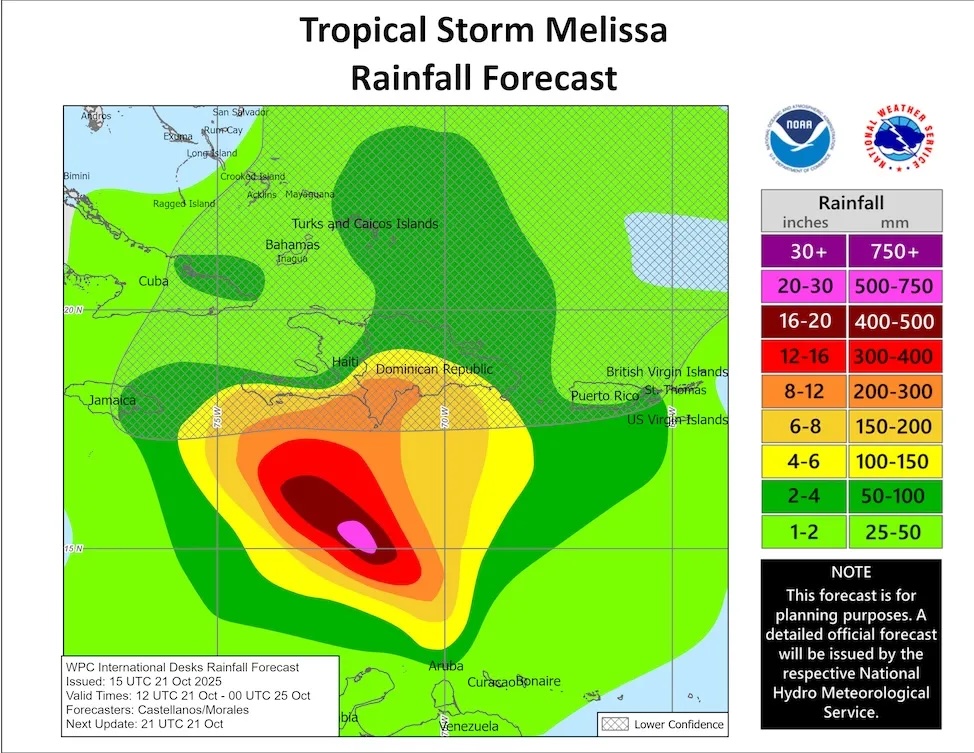
The many possibilities for Melissa’s future in the coming days include days of torrential rain in some of the most flood-prone locations in the Caribbean. Disastrous flooding and landslides are a threat not only in Haiti but also throughout the southern Dominican Republic. Melissa is not expected to pose a threat to the continental United States for at least next week due to strong wind shear caused by the subtropical jet stream moving eastward from Florida to the Bahamas, and ensemble models indicate only a small chance that the storm will reach far enough northwest to impact Florida.
Melissa was the 13th named storm of the 2025 Atlantic season, occurring just 4 days before the average arrival date of the season’s 13th named storm, October 25 (for the entire 1991-2020 period).
you may like
Record warmth in Caribbean boosts melissa growth
We are nearing the end of the Atlantic hurricane season, but the Caribbean is most likely to see named storms forming in mid-to-late October. This is because wind shear is typically too strong for tropical cyclones in more northern regions. At this point in the year, Caribbean ocean waters have typically not cooled much from their seasonal peak, but the wind shear that often makes the Caribbean a “graveyard” for early tropical systems has typically diminished.
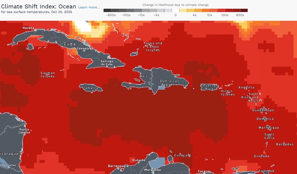
This week, Melissa is scheduled to cross the warmest waters ever recorded anywhere in the Atlantic Basin later this season. Average sea surface temperatures across the Caribbean were at least 0.5 degrees Celsius (0.9 degrees Fahrenheit) warmer as of Sunday, October 19, than in any year on that date except 2023 and 2024, according to an analysis by Kim Wood of the University of Arizona.
According to Climate Central’s Climate Change Index, current warming in the central Caribbean is an incredible 500 to 800 times more likely to occur due to anthropogenic climate change (see Figure 2).
Where will Melissa go?
If Melissa follows the National Hurricane Center’s original forecast released at 11 a.m. EDT Tuesday, it will enter the weekend (and possibly beyond) as it continues to intensify, slowly creeping just south of Haiti. This is a recipe for potentially catastrophic flooding and landslides in southern Hispaniola. Poverty, political instability, and deforestation make Haiti highly vulnerable to the disasters that Melissa may cause.
That said, the predictive models for Melissa’s future are not completely consistent (see Figure 3 below). Part of the problem is that until Tuesday there was no clear center of the storm. Melissa is a bona fide tropical cyclone, which may increase the amount of model agreement. However, the redirecting currents are likely to be weak, and slow-moving storms can pose problems for even the best forecast models.
Until early Tuesday, the European model continued to favor a slow westward course, and most of the members of the European model ensemble remained in the Caribbean until at least the following Monday, October 27th (left side of Figure 3), although a significant minority took Melissa to western Haiti. The GFS (America) model (right side of Figure 3) similarly claims that Melissa will turn northward and leave the Caribbean Sea, but the members of its ensemble vary widely regarding the timing and location of that turn. The Google DeepMind AI-based model has been the top performer on this year’s orbit, but it is tipped toward an eventual northward turn, although again there is wide variation in its timing and location among ensemble members.
Melissa’s strength forecast
Steady reinforcement seems like a safe bet for Melissa over the next few days. The storm is embedded in an unusually humid atmosphere, with moderate relative humidity expected to rise from 70 to 75 percent Tuesday to 80 percent by Wednesday. Wind shear was expected to be between 10 and 20 knots Tuesday afternoon and will remain moderate to high for several days. Upper-level high pressure is expected to build over the Caribbean Sea into the weekend, which will favor strengthening.
you may like
In addition to unusually warm surface waters, the Caribbean now has enough ocean heat to extend to significant depths, so even the slow-moving Melissa is unlikely to be significantly hampered by stirring up cooler groundwater. Although the NHC did not predict that Melissa would rapidly strengthen over the next five days, the SHIPS model forecast on Tuesday 18Z called for a 12% chance of a rapid strengthening of 35 mph within 24 hours and a 25% chance of a rapid strengthening of 75 mph within 72 hours. That would put Melissa at Category 3 strength Friday afternoon with winds of 195 mph.
If the forecast scenario of October’s “M” storm advancing into the Caribbean Sea, stalling, and heading north as a major hurricane sounds familiar, this outcome should be very similar to what we saw with Matthew in 2016. bmcnoldy.blogspot.com/2025/10/meli… #Melissa
— @bmcnoldy.bsky.social (@bmcnoldy.bsky.social.bsky.social) 2025-10-23T12:03:13.447Z
Late-season hurricane risk in the Caribbean
A slow-moving, late-season system that gains momentum in the Caribbean could cause untold trouble. In early October 2016, Hurricane Matthew moved north from far western Haiti as a Category 4 hurricane, dumping more than 20 inches (500 mm) of rain on much of far eastern Cuba and southwestern Haiti, and hitting the Bahamas and several other islands. Matthew claimed 731 lives and caused more than $16 billion in damage (2016 USD).
Just over 20 years ago, Hurricane Wilma intensified at an alarming rate in the northwestern Caribbean Sea, becoming a Category 5 monster. From October 18 to 19, 2005, Wilma increased in depth from 975 millibar (hPa) to 892 millibar (hPa) in 12 hours and from 979 millibar (hPa) to 882 millibar (hPa) in 24 hours, setting two historical records for rapidly intensifying Atlantic basins. In the latter case, Wilma became the strongest central pressure hurricane in Atlantic history. Wilma also set a record for maximum 24-hour wind speed increase, with maximum sustained wind speeds increasing from 75 mph to 175 mph. Wilma hit Mexico’s Yucatan Peninsula as a strong Category 4 storm and moved northeastward to Category 3 strength on October 24, hitting southwest Florida. Wilma killed 52 people and caused $26.5 billion (2005 USD) in damage.
Near the end of October 1998, Hurricane Mitch, formerly a Category 5, slowed and weakened, dropping enormous amounts of rain (30 to 40 inches, or 750 to 1000 millimeters in many areas) over Guatemala, Nicaragua, and Honduras, even as it slowed and weakened and made landfall at Category 1 strength. Floods and landslides have caused approximately $6 billion (1998 USD) in damage, with more than 11,000 confirmed deaths and an additional 11,000 missing. Mitch was probably the deadliest Atlantic hurricane of the satellite monitoring era (i.e., post-1960s) since the Great Hurricane of 1780.
This article was originally published by Yale Climate Connections.
Source link