
An international collaboration between Virginia Tech, USA and Bowen University, Nigeria is poised to highlight the use of High-Frequency (HF) radars on monitoring space weather.
This initiative emphasises advancing these techniques in equatorial Nigeria, a region characterised by unique ionospheric phenomena like the equatorial electrojet and ionisation anomalies, which are critical for understanding space weather impacts on low-latitude regions.
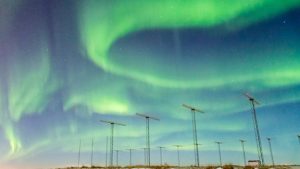
The near-space environment of Earth is dominated by the collision of magnetised plasma that constitutes the solar wind with Earth’s protective magnetic field. Turbulent conditions in the sun give rise to explosions of energy and matter, such as Coronal Mass Ejections (CMEs). The most powerful events result in compression and distortion of the volume of space carved out by the magnetic field, called the magnetosphere. Energy couples from the solar wind into the magnetosphere, where it is released in spectacular auroral displays and a range of other effects, some of them potentially harmful to humans in space and to technological systems.
Importance of space weather and space weather radar monitoring
The term ‘space weather’ encompasses both the study of the variable conditions in Earth’s space environment and their impacts. The latter include such well-known effects as radiation hazard to humans in space and to crews on high-altitude aircraft in the polar regions, disruption of electrical distribution systems, scintillations on the signals used for global navigation satellite systems (GNSS aka GPS) leading to unacceptable errors, and disruption of communication links and over-the-horizon (OTH) radar surveillance systems. As humanity ventures forth into space, it is imperative that the science of space weather advances to provide both knowledge of and protection against the harmful effects of space weather.
Scientific instruments are operated both from satellite platforms and from the ground to observe space weather effects. These include a category of High Frequency (HF) radar that makes measurements based on the backscattering of radio wave signals from the partially ionised plasma of the ionosphere at altitudes between 90 and 600km. The ionosphere effectively presents a screen for monitoring processes occurring throughout the vast volume of the magnetosphere.
An important manifestation of the coupling of the solar wind to the magnetosphere is the circulation of ionospheric plasma over large areas approximately centred on the north and south magnetic poles. This motion is analogous to winds in the lower atmosphere and can be depicted with maps that are very similar to tropospheric weather maps, with cells of high and low pressure driving the circulation.
However, the processes are electrical in nature, with pressure measured in kilovolts and speeds often measured in kilometres per second. The plasma circulation pattern is very sensitive to solar wind factors and expands and contracts with the level of disturbance in the magnetosphere. The international collaboration known as Super Dual Auroral Radar Network (SuperDARN) operates a network of HF radars as a space weather radar system that measures plasma motion in the ionosphere and maps the pattern of global circulation.
In addition, the sensitivity of HF propagation to ionospheric conditions affords many possibilities for observing disturbance effects related to space weather. The first HF radar was built in Labrador, Canada, in the 1980s. The international collaboration known as SuperDARN dates from the 1990s when partners from six countries agreed to deploy radars in the auroral zones and operate them on a common schedule to produce data for merging into a single stream shared by all.
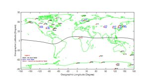
The collaboration now counts over 35 radars, ten countries, and 17 participating institutions and the radar coverage extends from polar latitudes through the auroral zones to the mid-latitude regions.
Transition of space weather radar monitoring to equatorial Nigeria
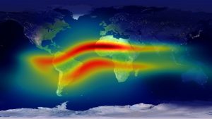
Space weather effects are prominent in the ionosphere in the vicinity of the geomagnetic equator. The special geometry of the magnetic field results in strong plasma flow and electric current in a belt that encircles the globe, as well as the formation of bubbles in ionospheric density that become structured and pose hazards for communication systems. It is known that geomagnetic storms penetrate the equatorial zone and cause disturbance effects in the ionosphere, some similar to those at high latitudes and some unique. The monitoring of space weather effects in the equatorial zone with ground-based instrumentation is very limited as landmass is limited, and much of that is inaccessible.
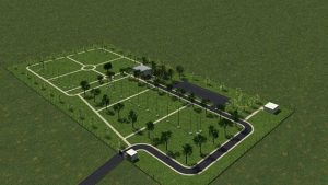
The plan to construct a space weather radar in Nigeria, specifically the Virginia Tech-Nigeria Bowen Equatorial Aeronomy Radar (VT-NigerBEAR), represents a major step forward in expanding capabilities to address this gap. The HF radar technique originally developed for the high latitude regions can be readily adapted to conditions in the equatorial ionosphere.
The name VT – NigerBEAR reflects the shared heritage and the hope for productive scientific collaboration within the international scientific community. VT-NigerBEAR will be the first radar on the SuperDARN design operating at low latitudes, and it will have a field of view that extends eastward across the continent. This initiative will not only be transformative for Nigeria; it will enable research across Africa and provide links to international research on both the low-latitude and global aspects of space weather.
It is important to note that communication and navigation technologies, town planning, resources, and disaster management are highly dependent on satellites operating in the space environment. Understanding the space environment through data collection and analysis has become a vital part of protecting our technologies in space and on Earth from the devastating effects of space weather and lower atmospheric forcing. VT-NigerBEAR can provide this essential service to the African low latitudes that house about 80% of African landmass through monitoring space weather activity to provide information for early warnings and forecasts about space weather and associated conditions in the lower atmosphere.
In addition to providing continuous monitoring, the VT-NigerBEAR radar, in co-ordination with the SuperDARN radars and other instrumentation, will enable new lines of research on the coupling of disturbance effects between the high and low latitude regions. VT-NigerBEAR will allow the assessment of phenomena such as ionospheric irregularities and thermospheric winds. Measurements of these kinds are very new to the low and equatorial latitudes in the African space weather community.
The scientific and technical concepts of VT-NigerBEAR
The ionosphere at equatorial latitudes is highly dynamic, owing to the horizontal orientation of the lines of force of the geomagnetic field. This special geometry results in a belt of heightened conductivity along which flows a strong electric current known as the equatorial electrojet (EEJ). Instabilities are triggered, which lead to the structuring of ionospheric plasma and disruption of radio wave propagation. The effects bear some similarity to the space weather at auroral latitudes in that the interplay of plasma, electric fields, neutral winds, and currents leads to mass displacement of plasma and the formation of density gradients and density irregularities that cause errors on radio wave systems such as GNSS.
The concept of the new radar is to adapt the HF technique developed at high latitudes, where the geomagnetic lines of force are nearly vertical, to the African equatorial zone, where they are nearly horizontal. The conditions for HF backscattering with a SuperDARN-type radar are readily satisfied in the equatorial ionosphere. The observation of backscatter from the ionosphere directly registers the presence of enhanced meter-scale density irregularities.
By virtue of the Doppler shift imposed on the signal, the radar can measure the plasma flow velocity in the equatorial electrojet. The propagation of the HF signal itself is extremely sensitive to ionospheric conditions.
A second backscatter mode that involves reflection by the ionosphere to the ground and a return along the same path will provide a means to monitor all manner of ionospheric disturbance. Construction of the VT-NigerBEAR radar will bring the full capabilities of the SuperDARN technique to bear on the study of space weather effects in the low latitude ionosphere.
All SuperDARN radars operating at high latitudes utilise two arrays of antennas that have a mostly east-west orientation in order to form a beam that can be scanned electronically in azimuth about the direction of either the north or south magnetic pole. The antenna design produces peak antenna gain at a fairly low elevation angle. The second array does not transmit but receives a backscattered signal that can be compared with the main array’s signal to determine the elevation angle of the backscatter.
This configuration is appropriate for high latitudes with its nearly vertical geomagnetic field lines. The condition for backscattering is that the HF signal propagates orthogonally to the field lines where meter-scale density irregularities are encountered.
A SuperDARN-type radar operating in the ionosphere at equatorial latitudes must satisfy the same backscattering condition. With the field lines now horizontal and running north-south, the arrays need to be oriented in a north-south sense in order to form a beam that is directed east or west so that the HF signal is directed across the field lines at the appropriate angle. The VT-NigerBEAR radar will be directed eastward to look across the bulk of equatorial Africa.
At the equator, scanning in elevation is of heightened importance, as the electrojet will pass directly over the site on an east-to-west arc. [5] + [6] Consequently, the VT – NigerBEAR radar will be configured with three arrays oriented north-south, all of which are capable of transmitting and receiving. In addition, the antennas have been re-designed to increase sensitivity over a wider range of elevation angles. These are the most significant adaptations for operating at the equator.
Benefits to the Nigerian and International space weather community
VT-NigerBEAR is poised to become a cornerstone of space weather research in Nigeria, providing critical support for other space weather studies and measurements. By integrating with GPS receivers, magnetometers, meteorological instruments, and other tools, VT-NigerBEAR will enhance our understanding of space weather phenomena and their impacts on technological systems. VT-NigerBEAR will be capable of scanning in azimuth to cover the peaks in ionisation density that occur at latitudes just above and below the equator. This phenomenon, known as the Equatorial Ionization Anomaly (EIA) is due to upward plasma drift at the equator that also stimulates the formation of plasma voids known as bubbles. The HF radar will be sensitive to perturbations in the ionosphere that accompany, and help to explain, these dramatic features.
By combining VT-NigerBEAR’s high-resolution data on plasma density bubbles with GPS TEC measurements, researchers can better understand the mechanisms behind scintillations – rapid fluctuations in GNSS signals caused by ionospheric irregularities in the low latitudes. This integration will improve models for mitigating GNSS errors, benefiting applications such as aviation, maritime navigation, and precision agriculture. Magnetometers provide insights into the strength and direction of Earth’s magnetic field, while VT-NigerBEAR measures plasma flows and electric currents. Together, these instruments offer a comprehensive view of storm-time ionospheric dynamics.
A novel area of research enabled by VT-NigerBEAR is the study of how Sudden Stratospheric Warming (SSW) events influence ionospheric irregularities in low-latitude regions. Traditionally studied in polar and mid-latitude regions, these events have been hypothesised to affect equatorial plasma dynamics. VT-NigerBEAR will also detect atmospheric gravity waves and tides — the former via the ground backscatter mode and the latter via reflection from meteor trails drifting with winds at mesospheric altitudes — providing insights into their sources and propagation characteristics. VT-NigerBEAR will provide direct evidence of the coupling of ion motions and neutral winds, potentially uncovering new mechanisms of energy transfer between the lower atmosphere and the ionosphere.
The VT-NigerBEAR radar will operate continuously (like the SuperDARN radars) and generate a rich database of observations for understanding space weather effects in the equatorial zone. The flow of plasma in the equatorial electrojet across the African sector will be monitored with a spatial resolution of kilometers and a temporal resolution of seconds. The measurements will include vertical drift of the ionosphere, enhancing our understanding of how this parameter controls the ionospheric density distribution, plasma instability, the formation of irregularities, and the onset of scintillations. The high-quality, continuous data provided by VT-NigerBEAR will be invaluable for validating and refining existing space weather models and enhancing the accuracy of space weather forecasting.
VT-NigerBEAR’s data will enable comparisons with high- and mid-latitude observations, revealing how space weather effects vary across different regions. This global perspective improves our understanding of data variations around low, middle, and high latitudes. Its unique location in the equatorial region, combined with its advanced capabilities, makes it an invaluable asset for advancing scientific knowledge and fostering collaboration both within Nigeria and internationally.
Summary
VT-NigerBEAR represents a landmark achievement for the Nigerian and international space science communities. By addressing critical gaps in observational coverage, enabling groundbreaking research, and fostering collaboration, the radar will significantly advance our understanding of space weather and atmospheric dynamics. Its impact will extend beyond scientific discovery, contributing to the protection of technological systems, the development of skilled workforces, and the promotion of sustainable development.
Through VT-NigerBEAR, Nigeria is poised to become a global leader in low-latitude space science, while the international community benefits from enhanced capabilities to monitor and mitigate the effects of space weather on modern society.
Authors
1. W.A. Scales
Center for Space Science and Engineering Research
Bradley Department of Electrical and Computer Engineering
Virginia Tech, Blacksburg, Virginia
J.M Ruohoniemi
Center for Space Science and Engineering Research
Bradley Department of Electrical and Computer Engineering
Virginia Tech, Blacksburg, Virginia
K. Sterne
Center for Space Science and Engineering Research
Bradley Department of Electrical and Computer Engineering
Virginia Tech, Blacksburg, Virginia
O.S. Bolaji
College of Agriculture, Engineering and Science,
Physics Programme, Bowen University, Iwo. Nigeria.
Babatunde Rabiu
1 National Space Research and Development Agency, Abuja, Nigeria
2 College of Agriculture, Engineering and Science,
Physics Programme, Bowen University, Iwo. Nigeria.
J.B. Fashae
College of Agriculture, Engineering and Science,
Physics Programme, Bowen University, Iwo. Nigeria.
O.O. Ajani
College of Agriculture, Engineering and Science,
Physics Programme, Bowen University, Iwo. Nigeria.
Please note, this article will also appear in the 22nd edition of our quarterly publication.
Source link